Sark South Meadows 1
SARK PROJECTS HOUSING LLP · Rangareddy · RERA P02400007559
SARK SOUTH MEADOWS 1 is a residential villa project in Kongarakurdu, Maheshwaram Mandal, Ranga Reddy District. It is being developed by the registered promoter SARK PROJECTS HOUSING LLP. The project has a registered land area of 44,055.47 sq. m and records 165 duplex-villa units, with saleable areas of 183.74–186.56 sq. m. Its TG-RERA registration number is P02400007559, and the promoter’s proposed completion date is 10 July 2028.
📘 Project brochure from the promoter’s website ↗More from Sark Projects Housing LLP · 4 projects →
01What we found
Read from TG-RERA filings, approvals, land and registration records and court records. A court case is counted only when the court record states this project's survey number with its village, or names the project.
02Check before you pay
8 items to check before you pay, 4 high - from the title chain, court records and approvals, each with what to ask the builder or your advocate. An item may not be a problem with the project: records can be incomplete.
1. Project at a glance
Project identity
| Item | Project record |
|---|---|
| Registered project name | SARK SOUTH MEADOWS 1 RERA record |
| Project type / phase | Residential villa project; the supplied RERA record identifies “New Project.” A separate phase or phase name is not disclosed. RERA record RERA filing |
| TG-RERA registration | P02400007559; registered 10 January 2024, valid through 10 July 2028. Registration validity is distinct from the promoter’s completion undertaking. RERA record |
| RERA status | Registration certificate on file. The supplied record does not state that the registration has been extended. |
| Registered promoter | SARK PROJECTS HOUSING LLP, an LLP. RERA record Corporate record |
Land and geographic identity
| Item | Project record |
|---|---|
| Locality / revenue village | Kongarakhurd / Kongarakurdu; the layout and approval documents also spell the village “Kongarakurdhu” or “KongaraKhurd.” The certificate records Kongarakurdu. RERA record |
| Mandal / district / PIN | Maheshwaram Mandal, Ranga Reddy District, 501359. RERA record |
| Project survey numbers | Old Sy. Nos. 367/P, 368, 369/P, 370 and 371; New Sy. Nos. 613/P, 610, 611/P, 612 and 614. RERA record |
| Registered land extent | RERA project information records total area 44,055.47 sq. m, affected area 1,518.86 sq. m, and net area 42,536.61 sq. m. RERA filing |
| Layout-plan area figures | The filed layout-plan extraction states total land area (44,055.47 Sqmts) 10 Ac 35.45 Gts, road widening 1.516.86 Samts [as extracted], and net land area (42,538.61 Sqmts) 10 Ac 20.44 Gts. |
| Boundaries | East: Pragathi Godown; West: Kotagalla Yadaiah and others; North: RWS Road; South: MNR Ventures and Others. RERA filing |
Development identity
| Item | Project record |
|---|---|
| Sanctioning authority / principal approval | Hyderabad Metropolitan Development Authority (HMDA), Draft Layout Permit No. 24/LO/Plg/HMDA/2023, dated 10.07.2023. It is described as draft layout permission for housing in a gated community with a compound wall. Approvals record |
| Site-area and layout breakdown | Filed layout drawing states plotted area 25,588.98 Sqmts (60.15%), amenities area 1.280 Samts (03.01%), open area 4.324.76 Samts (10.16%), utilities area 474 AQ Camte, and roads area 10,870.19 Sqmts (25.56%), as transcribed in the extraction. |
| Villas / units | RERA unit inventory records 165 duplex-villa units and three additional entries labelled “FIRST FLOOR,” “GROUND FLOOR,” and “SECOND FLOOR”; those three entries are not identified as villas for sale. RERA unit table RERA unit table |
| Approved built-up area | RERA project information records approved built-up area 32,033.81 sq. m. RERA filing |
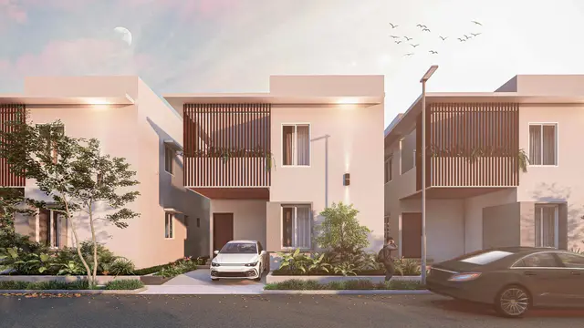
| Building form | Sample villa drawings show ground floor, first floor and terrace floor. Individual examples give proposed heights of 6.95 MTS and building areas including 176.36 SQMTS and 179.95 SQMTS; these are sample drawing-specific figures, not a complete schedule for all villas. |
| Parking / mortgage | RERA information records mortgage area 2,739.01 sq. m. The HMDA draft-layout letter identifies Villas Nos. 1–9 and 157–165 as mortgaged to HMDA; it does not provide a project-wide parking count. RERA filing |
Offering and status
| Item | Project record |
|---|---|
| RERA-filed configuration | Duplex villa; saleable area 183.74–186.56 sq. m. The filing contains 165 units, of which 66 are booked and 99 available in the portal extract. RERA unit table RERA unit details |
| Bookings / availability | RERA portal figures: 66 booked / 99 available for duplex villas. The extract supplies no as-of date, so counts are indicative. The three floor-labelled inventory entries are not counted here as homes on sale. RERA unit table RERA unit table |
| Construction stage | No independently verified site-progress report is supplied. RERA portal progress categories report internal roads and footpaths 45%, water supply 45%, sewerage 15%, sewage/sullage treatment and disposal 20%, community buildings 9%, and electrical meter room/sub-station/receiving station 40%; these are filed progress figures, not independent site verification. RERA amenities |
| Completion date | The promoter’s Form B declaration undertakes completion by 10 July 2028. |
| Occupancy / completion certificate | No occupancy certificate or completion certificate is included in the supplied project documents. The available HMDA permission is a draft-layout approval, not an occupancy certificate. Document index |
2. The project story
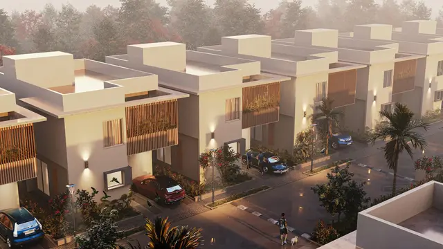
SARK SOUTH MEADOWS 1 is registered as a residential villa development in Kongarakurdu, Maheshwaram Mandal, Ranga Reddy District. The project land is identified in the RERA certificate by both old and new survey numbers, and the HMDA document describes a gated-community housing layout with a compound wall. The layout drawing shows roads, open space, amenities and utilities as part of the development plan. RERA record
The RERA inventory and booking details are recorded above. The project’s registration is valid through 10 July 2028; separately, the promoter’s Form B states a completion undertaking for that date. The evidence pack contains progress percentages for certain infrastructure and community-building categories, but no independently verified site inspection or occupancy/completion certificate. RERA unit table RERA amenities
3. Master plan, architecture & building design
The filed layout plan depicts a villa community and assigns areas to plots, roads, open space, amenities and utilities. Its extracted figures include 25,588.98 Sqmts (60.15%) plotted area, 4.324.76 Samts (10.16%) open area and 10,870.19 Sqmts (25.56%) roads area; some area labels are visibly garbled in the extraction and are reproduced as recorded rather than normalized.
The HMDA letter establishes draft Layout Permit No. 24/LO/Plg/HMDA/2023, dated 10.07.2023, for a gated-community housing layout. Its conditions state that the developer is responsible for developing the layout and infrastructure, and require development of amenities before release of the final layout. The supplied record does not establish that the final layout has been released.
Sample villa plans show ground, first and terrace floors. For example, the Villa No. 78 drawing records a plot area of 219.23 SQMTS (OR) 262 SQYDS, proposed height 6.95 MTS, and total building area 176.36 SQMTS; the Villa No. 59 drawing records proposed height 6.95 MTS and total area 179.95 SQMTS. These are individual drawing examples and should not be treated as a project-wide villa schedule.
The RERA record lists approved built-up area as 32,033.81 sq. m. The supplied material does not provide a complete project-wide schedule of floor configurations, villa-by-villa heights, parking levels or building footprint. RERA filing Document index
4. Homes, configurations & floor plans
| Configuration | Units | Booked | Available | RERA saleable area | Measured carpet area | Loading (if supplied) |
|---|---|---|---|---|---|---|
| Duplex villa | 165 | 66 | 99 | 183.74–186.56 sq. m | Not measured | Not supplied |
The RERA unit list records two duplex-villa labels (“DUPLEX VILLA” and “DUPLEX VILLLA”). It also contains one each of “FIRST FLOOR,” “GROUND FLOOR” and “SECOND FLOOR,” each with a recorded saleable area of 411.9 sq. m; these are floor labels, not additional homes counted in the duplex-villa offering. RERA unit table RERA unit table
Carpet-area measurements from drawings are not available: all 12 drawing records are scans pending measurement. The RERA saleable-area figures above are therefore not drawing-measured carpet areas. Saleable area and carpet area are distinct measures; the supplied record does not provide a loading figure. Floor plans RERA unit details
5. Parking & vehicle circulation
The layout drawing and HMDA permission identify internal roads, including listed widths of 9.14m, 12.19m, 15.24 and “30.0 mi-88 fiNe road” in the layout extraction; the HMDA letter also refers to an affected proposed 100 feet wide road and internal roads of 18 mts and above.
The supplied evidence does not establish sanctioned car or two-wheeler parking counts, visitor or accessible spaces, parking levels, ramps, EV charging, or a buyer-specific parking allocation. The HMDA letter identifies Villas Nos. 1–9 and Nos. 157–165 as mortgaged villas; this is not a parking allocation.
6. Amenities, recreation & open spaces
| Description / size | Layout circulation; area figures are recorded in the layout drawing. |
|---|---|
| Evidence source | RERA progress record; |
| Declared progress / verified status | 45% reported in the RERA progress extract; not independently verified. RERA amenities |
| Description / size | Internal water supply is named in the HMDA conditions; no capacity is supplied. |
|---|---|
| Evidence source | HMDA draft-layout letter |
| Declared progress / verified status | 45% reported in the RERA progress extract; not independently verified. RERA amenities |
| Description / size | HMDA document lists underground drainage lines, common septic tank/STP and independent sewerage disposal. |
|---|---|
| Evidence source | HMDA draft-layout letter |
| Declared progress / verified status | Sewerage 15%; treatment and disposal of sewage/sullage 20% reported; not independently verified. RERA amenities |
| Description / size | Listed as a layout infrastructure item. |
|---|---|
| Evidence source | HMDA draft-layout letter |
| Declared progress / verified status | 0% reported in the RERA progress extract; not independently verified. RERA amenities |
| Description / size | Layout drawing lists “TOT-LOT”; HMDA document lists avenue plantation and park development. |
|---|---|
| Evidence source | RERA layout drawing; HMDA draft-layout letter |
| Declared progress / verified status | Green strip/tot lot/park 0% reported; not independently verified. RERA amenities |
| Description / size | The layout drawing identifies amenities area; the HMDA letter requires amenities to be developed before final-layout release. |
|---|---|
| Declared progress / verified status | Community buildings 9% reported; not independently verified. RERA amenities |
| Description / size | Layout plan records 4.324.76 Samts (10.16%) as extracted. |
|---|---|
| Declared progress / verified status | Aggregate recreational open-space progress reported as 0%; not independently verified. RERA amenities |
| Description / size | Layout extraction records “474 AQ Camte.” |
|---|---|
| Declared progress / verified status | No separate completion percentage supplied. |
7. Utilities, building services & safety
The HMDA draft-layout letter lists proposed storm-water drains, underground drainage lines, common septic tank/STP, internal water-supply pipelines, overhead tank, electrical supply lines, street lights, transformer, avenue plantation, park development, rainwater-harvesting pits, protected water supply, sumps and underground ducting of utilities. These are approval-document descriptions of proposed infrastructure, not proof of installation or operation.
The RERA progress extract reports water supply at 45%, sewerage at 15%, sewage/sullage treatment and disposal at 20%, and electrical meter room/sub-station/receiving station at 40%. Storm-water drains, solid-waste management, water conservation/rainwater harvesting, energy management and fire-protection/safety each show 0% where a percentage is supplied. These percentages are portal-reported and are not independently verified. RERA amenities
No capacities are supplied for water storage or treatment, STP, electrical backup, fire systems or waste facilities. The supplied evidence does not establish lift provision, fire-clearance status, CCTV, access-control systems, accessibility features or completed life-safety installations. RERA amenities Document index
8. Location, access & connectivity
The registered location is Kongarakurdu, Maheshwaram Mandal, Ranga Reddy District, Telangana 501359. The project boundary information identifies RWS Road to the north; the other recorded boundaries are Pragathi Godown to the east, Kotagalla Yadaiah and others to the west, and MNR Ventures and Others to the south. RERA record RERA filing
The supplied location data gives the nearest sampled Outer Ring Road interchange at approximately 3.3 km. This is a supplied approximate distance, not a travel-time estimate. Location record
9. Developer & development status
The registered legal promoter is SARK PROJECTS HOUSING LLP, an LLP, with GSTIN 36AENFS2493G1ZL. Its project-record address is 6th Floor, Botanical Garden, Kongarakhurd, Maheshwaram, Ranga Reddy, 501359. Sarin Katta is listed as authorized signatory, and Smitha Reddy Katta as partner. Corporate record Parties record
The promoter’s Form B, signed by Sarin Katta, names five landowners and undertakes completion by 10 July 2028. The registration certificate is valid through the same date. The supplied RERA progress categories report infrastructure percentages, but the evidence does not include independent verification of construction progress or a completion/occupancy certificate. RERA amenities
10. Approvals, official records & documents
| Record | What the supplied evidence establishes |
|---|---|
| TG-RERA registration certificate | Form C for SARK SOUTH MEADOWS 1, registration P02400007559, valid 10 January 2024 to 10 July 2028; identifies the promoter and project survey numbers. |
| HMDA draft layout permission | Draft Layout Permit No. 24/LO/Plg/HMDA/2023, dated 10.07.2023, for a gated-community housing layout; includes development conditions and HMDA-mortgaged villas. |
| Filed layout drawing | Layout plan with land-use areas, internal roads, amenities, utilities, survey numbers and a note of nine proposed regular-mortgage plots. |
| Villa building-plan drawings | Sample villa plans include Villa Nos. 41, 59, 78, 115, 116 and 156, alongside other extracted layout/building-plan sheets; several state that technical approval is forwarded to the municipality/local body for final sanction. |
| Promoter Form B declaration | Form-B affidavit by Sarin Katta for SARK PROJECTS HOUSING LLP, dated August 2023, naming five landowners and stating the completion undertaking. |
| Occupancy/completion certificate | None supplied for the project. The supplied HMDA record is a draft-layout permission; it is not an occupancy or completion certificate. Document index |
1. Project at a glance
Project identity
Registered project name: SARK SOUTH MEADOWS 1
Project type / phase: Residential villa project; the supplied RERA record identifies “New Project.” A separate phase or phase name is not disclosed.
TG-RERA registration: P02400007559; registered 10 January 2024, valid through 10 July 2028. Registration validity is distinct from the promoter’s completion undertaking.
RERA status: Registration certificate on file. The supplied record does not state that the registration has been extended.
Registered promoter: SARK PROJECTS HOUSING LLP, an LLP.
Land and geographic identity
Locality / revenue village: Kongarakhurd / Kongarakurdu; the layout and approval documents also spell the village “Kongarakurdhu” or “KongaraKhurd.” The certificate records Kongarakurdu.
Mandal / district / PIN: Maheshwaram Mandal, Ranga Reddy District, 501359.
Project survey numbers: Old Sy. Nos. 367/P, 368, 369/P, 370 and 371; New Sy. Nos. 613/P, 610, 611/P, 612 and 614.
Registered land extent: RERA project information records total area 44,055.47 sq. m, affected area 1,518.86 sq. m, and net area 42,536.61 sq. m.
Layout-plan area figures: The filed layout-plan extraction states total land area (44,055.47 Sqmts) 10 Ac 35.45 Gts, road widening 1.516.86 Samts [as extracted], and net land area (42,538.61 Sqmts) 10 Ac 20.44 Gts.
Boundaries: East: Pragathi Godown; West: Kotagalla Yadaiah and others; North: RWS Road; South: MNR Ventures and Others.
Development identity
Sanctioning authority / principal approval: Hyderabad Metropolitan Development Authority (HMDA), Draft Layout Permit No. 24/LO/Plg/HMDA/2023, dated 10.07.2023. It is described as draft layout permission for housing in a gated community with a compound wall.
Site-area and layout breakdown: Filed layout drawing states plotted area 25,588.98 Sqmts (60.15%), amenities area 1.280 Samts (03.01%), open area 4.324.76 Samts (10.16%), utilities area 474 AQ Camte, and roads area 10,870.19 Sqmts (25.56%), as transcribed in the extraction.
Villas / units: RERA unit inventory records 165 duplex-villa units and three additional entries labelled “FIRST FLOOR,” “GROUND FLOOR,” and “SECOND FLOOR”; those three entries are not identified as villas for sale.
Approved built-up area: RERA project information records approved built-up area 32,033.81 sq. m.
Building form: Sample villa drawings show ground floor, first floor and terrace floor. Individual examples give proposed heights of 6.95 MTS and building areas including 176.36 SQMTS and 179.95 SQMTS; these are sample drawing-specific figures, not a complete schedule for all villas.
Parking / mortgage: RERA information records mortgage area 2,739.01 sq. m. The HMDA draft-layout letter identifies Villas Nos. 1–9 and 157–165 as mortgaged to HMDA; it does not provide a project-wide parking count.
Offering and status
RERA-filed configuration: Duplex villa; saleable area 183.74–186.56 sq. m. The filing contains 165 units, of which 66 are booked and 99 available in the portal extract.
Bookings / availability: RERA portal figures: 66 booked / 99 available for duplex villas. The extract supplies no as-of date, so counts are indicative. The three floor-labelled inventory entries are not counted here as homes on sale.
Construction stage: No independently verified site-progress report is supplied. RERA portal progress categories report internal roads and footpaths 45%, water supply 45%, sewerage 15%, sewage/sullage treatment and disposal 20%, community buildings 9%, and electrical meter room/sub-station/receiving station 40%; these are filed progress figures, not independent site verification.
Completion date: The promoter’s Form B declaration undertakes completion by 10 July 2028.
Occupancy / completion certificate: No occupancy certificate or completion certificate is included in the supplied project documents. The available HMDA permission is a draft-layout approval, not an occupancy certificate.
2. The project story
SARK SOUTH MEADOWS 1 is registered as a residential villa development in Kongarakurdu, Maheshwaram Mandal, Ranga Reddy District. The project land is identified in the RERA certificate by both old and new survey numbers, and the HMDA document describes a gated-community housing layout with a compound wall. The layout drawing shows roads, open space, amenities and utilities as part of the development plan.
The RERA inventory and booking details are recorded above. The project’s registration is valid through 10 July 2028; separately, the promoter’s Form B states a completion undertaking for that date. The evidence pack contains progress percentages for certain infrastructure and community-building categories, but no independently verified site inspection or occupancy/completion certificate.
3. Master plan, architecture & building design
The filed layout plan depicts a villa community and assigns areas to plots, roads, open space, amenities and utilities. Its extracted figures include 25,588.98 Sqmts (60.15%) plotted area, 4.324.76 Samts (10.16%) open area and 10,870.19 Sqmts (25.56%) roads area; some area labels are visibly garbled in the extraction and are reproduced as recorded rather than normalized.
The HMDA letter establishes draft Layout Permit No. 24/LO/Plg/HMDA/2023, dated 10.07.2023, for a gated-community housing layout. Its conditions state that the developer is responsible for developing the layout and infrastructure, and require development of amenities before release of the final layout. The supplied record does not establish that the final layout has been released.
Sample villa plans show ground, first and terrace floors. For example, the Villa No. 78 drawing records a plot area of 219.23 SQMTS (OR) 262 SQYDS, proposed height 6.95 MTS, and total building area 176.36 SQMTS; the Villa No. 59 drawing records proposed height 6.95 MTS and total area 179.95 SQMTS. These are individual drawing examples and should not be treated as a project-wide villa schedule.
The RERA record lists approved built-up area as 32,033.81 sq. m. The supplied material does not provide a complete project-wide schedule of floor configurations, villa-by-villa heights, parking levels or building footprint.
4. Homes, configurations & floor plans
| Configuration | Units | Booked | Available | RERA saleable area | Measured carpet area | Loading (if supplied) |
|---|---|---|---|---|---|---|
| Duplex villa | 165 | 66 | 99 | 183.74–186.56 sq. m | Not measured | Not supplied |
The RERA unit list records two duplex-villa labels (“DUPLEX VILLA” and “DUPLEX VILLLA”). It also contains one each of “FIRST FLOOR,” “GROUND FLOOR” and “SECOND FLOOR,” each with a recorded saleable area of 411.9 sq. m; these are floor labels, not additional homes counted in the duplex-villa offering.
Carpet-area measurements from drawings are not available: all 12 drawing records are scans pending measurement. The RERA saleable-area figures above are therefore not drawing-measured carpet areas. Saleable area and carpet area are distinct measures; the supplied record does not provide a loading figure.
5. Parking & vehicle circulation
The layout drawing and HMDA permission identify internal roads, including listed widths of 9.14m, 12.19m, 15.24 and “30.0 mi-88 fiNe road” in the layout extraction; the HMDA letter also refers to an affected proposed 100 feet wide road and internal roads of 18 mts and above.
The supplied evidence does not establish sanctioned car or two-wheeler parking counts, visitor or accessible spaces, parking levels, ramps, EV charging, or a buyer-specific parking allocation. The HMDA letter identifies Villas Nos. 1–9 and Nos. 157–165 as mortgaged villas; this is not a parking allocation.
6. Amenities, recreation & open spaces
| Description / size | Layout circulation; area figures are recorded in the layout drawing. |
|---|---|
| Evidence source | RERA progress record; |
| Declared progress / verified status | 45% reported in the RERA progress extract; not independently verified. |
| Description / size | Internal water supply is named in the HMDA conditions; no capacity is supplied. |
|---|---|
| Evidence source | HMDA draft-layout letter |
| Declared progress / verified status | 45% reported in the RERA progress extract; not independently verified. |
| Description / size | HMDA document lists underground drainage lines, common septic tank/STP and independent sewerage disposal. |
|---|---|
| Evidence source | HMDA draft-layout letter |
| Declared progress / verified status | Sewerage 15%; treatment and disposal of sewage/sullage 20% reported; not independently verified. |
| Description / size | Listed as a layout infrastructure item. |
|---|---|
| Evidence source | HMDA draft-layout letter |
| Declared progress / verified status | 0% reported in the RERA progress extract; not independently verified. |
| Description / size | Layout drawing lists “TOT-LOT”; HMDA document lists avenue plantation and park development. |
|---|---|
| Evidence source | RERA layout drawing; HMDA draft-layout letter |
| Declared progress / verified status | Green strip/tot lot/park 0% reported; not independently verified. |
| Description / size | The layout drawing identifies amenities area; the HMDA letter requires amenities to be developed before final-layout release. |
|---|---|
| Declared progress / verified status | Community buildings 9% reported; not independently verified. |
| Description / size | Layout plan records 4.324.76 Samts (10.16%) as extracted. |
|---|---|
| Declared progress / verified status | Aggregate recreational open-space progress reported as 0%; not independently verified. |
| Description / size | Layout extraction records “474 AQ Camte.” |
|---|---|
| Declared progress / verified status | No separate completion percentage supplied. |
7. Utilities, building services & safety
The HMDA draft-layout letter lists proposed storm-water drains, underground drainage lines, common septic tank/STP, internal water-supply pipelines, overhead tank, electrical supply lines, street lights, transformer, avenue plantation, park development, rainwater-harvesting pits, protected water supply, sumps and underground ducting of utilities. These are approval-document descriptions of proposed infrastructure, not proof of installation or operation.
The RERA progress extract reports water supply at 45%, sewerage at 15%, sewage/sullage treatment and disposal at 20%, and electrical meter room/sub-station/receiving station at 40%. Storm-water drains, solid-waste management, water conservation/rainwater harvesting, energy management and fire-protection/safety each show 0% where a percentage is supplied. These percentages are portal-reported and are not independently verified.
No capacities are supplied for water storage or treatment, STP, electrical backup, fire systems or waste facilities. The supplied evidence does not establish lift provision, fire-clearance status, CCTV, access-control systems, accessibility features or completed life-safety installations.
8. Location, access & connectivity
The registered location is Kongarakurdu, Maheshwaram Mandal, Ranga Reddy District, Telangana 501359. The project boundary information identifies RWS Road to the north; the other recorded boundaries are Pragathi Godown to the east, Kotagalla Yadaiah and others to the west, and MNR Ventures and Others to the south.
The supplied location data gives the nearest sampled Outer Ring Road interchange at approximately 3.3 km. This is a supplied approximate distance, not a travel-time estimate.
9. Developer & development status
The registered legal promoter is SARK PROJECTS HOUSING LLP, an LLP, with GSTIN 36AENFS2493G1ZL. Its project-record address is 6th Floor, Botanical Garden, Kongarakhurd, Maheshwaram, Ranga Reddy, 501359. Sarin Katta is listed as authorized signatory, and Smitha Reddy Katta as partner.
The promoter’s Form B, signed by Sarin Katta, names five landowners and undertakes completion by 10 July 2028. The registration certificate is valid through the same date. The supplied RERA progress categories report infrastructure percentages, but the evidence does not include independent verification of construction progress or a completion/occupancy certificate.
10. Approvals, official records & documents
TG-RERA registration certificate: Form C for SARK SOUTH MEADOWS 1, registration P02400007559, valid 10 January 2024 to 10 July 2028; identifies the promoter and project survey numbers.
HMDA draft layout permission: Draft Layout Permit No. 24/LO/Plg/HMDA/2023, dated 10.07.2023, for a gated-community housing layout; includes development conditions and HMDA-mortgaged villas.
Filed layout drawing: Layout plan with land-use areas, internal roads, amenities, utilities, survey numbers and a note of nine proposed regular-mortgage plots.
Villa building-plan drawings: Sample villa plans include Villa Nos. 41, 59, 78, 115, 116 and 156, alongside other extracted layout/building-plan sheets; several state that technical approval is forwarded to the municipality/local body for final sanction.
Promoter Form B declaration: Form-B affidavit by Sarin Katta for SARK PROJECTS HOUSING LLP, dated August 2023, naming five landowners and stating the completion undertaking.
Occupancy/completion certificate: None supplied for the project. The supplied HMDA record is a draft-layout permission; it is not an occupancy or completion certificate.
Frequently asked questions
Is SARK SOUTH MEADOWS 1 registered with Telangana RERA?
Yes. SARK SOUTH MEADOWS 1 is registered with the Telangana Real Estate Regulatory Authority as P02400007559; the registration status is New Project.
Who is the developer of SARK SOUTH MEADOWS 1?
The promoter named in the RERA registration is SARK PROJECTS HOUSING LLP.
Where is SARK SOUTH MEADOWS 1 located?
SARK SOUTH MEADOWS 1 is in Kongarakhurd, Kongarakurdu, Maheshwaram, Rangareddy, Telangana (501359).
When will SARK SOUTH MEADOWS 1 be completed?
The promoter's proposed date of completion filed with RERA is 10/11/2028. This is the promoter's declaration, not a guarantee.