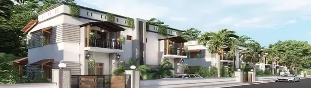
Nature View
RAMAKRISHNA REDDY ANUGU · Rangareddy · RERA P02400007230
NATURE VIEW is a plotted development in ABDULLLAPURMET, Abdullapurmet Mandal, Ranga Reddy District. The registered promoter is RAMAKRISHNA REDDY ANUGU, a Proprietorship. The project covers 13640.46 sq. m and is arranged as 45 plots; plot-size configurations are not stated. Its TG-RERA registration is P02400007230, issued 08/11/2023, and the promoter’s Form B states completion by 26/06/2026.
01What we found
Read from TG-RERA filings, approvals, land and registration records and court records. A court case is counted only when the court record states this project's survey number with its village, or names the project.
02Check before you pay
8 items to check before you pay, 4 high - from the title chain, court records and approvals, each with what to ask the builder or your advocate. An item may not be a problem with the project: records can be incomplete.
1. Project at a glance
Project identity
| Field | Project record |
|---|---|
| Registered project name | NATURE VIEW RERA record |
| Project type / registered portion | Plotted development; the registration identifies a project on part of Survey No. 280 RERA record |
| TG-RERA registration | P02400007230; registration certificate issued 08/11/2023 RERA record |
| Registration validity | 08/11/2023–26/06/2026; the supplied certificate records no extension. This is the registration-validity period, distinct from the promoter’s completion undertaking. |
| Registered promoter / entity type | RAMAKRISHNA REDDY ANUGU; Proprietorship RERA record RERA filing |
| RERA project status | “New Project” in the RERA record RERA record |
Land and geographic identity
| Field | Project record |
|---|---|
| Locality | ABDULLLAPURMET RERA record |
| Revenue village | Bandaravirala; the filed approval documents also spell the village Bandaraviryal. RERA record |
| Mandal / district / PIN | Abdullapurmet / Ranga Reddy / 501505 RERA record |
| Project survey number and subdivision | 280/PART; the approval documents refer to Sy.No. 280/PART and Sy.No. 280/part. RERA record |
| Registered site extent | 13640.46 sq. m RERA filing |
| Total / net area in filed layout approval | Total site area 13640.46 sq. m; net site area 13640.46 sq. m; master plan road affected area 0. |
| Boundaries recorded in RERA fields | East: ROAD WIDTH - 100; West, North and South: OTHERS LAND RERA filing |
Development identity
| Field | Project record |
|---|---|
| Sanctioning authority | Hyderabad Metropolitan Development Authority (HMDA); the approval record assigns further release action to Bandaraviryal Gramapanchayath. Approvals record |
| Principal approval | Draft layout Letter, approval no. 000128/LO/Plg/HMDA/2023, dated 27 June, 2023 |
| Panchayat proceedings | Draft technical layout pattern proceedings dated 22.09.2023, referring to the same layout permit number |
| Approved built-up area | 9248.3 sq. m is recorded in the RERA fields as approved built-up area; the layout approval separately labels 9248.3 as plotted area. These are not interchangeable area descriptions. RERA filing |
| Building / floor configuration | Not disclosed as a building scheme in the supplied project record; this is a plotted layout. The approval gives residential plot parameters, not a project-wide tower or floor schedule. RERA record |
| Parking provision | No parking-space count or allocation is established in the supplied layout and RERA extracts. |
| Layout plots | 45 plots are recorded in the Gram Panchayat proceedings. |
Offering and status
| Field | Project record |
|---|---|
| Unit type | Plots RERA record |
| Plot-size range | Not established by the supplied RERA fields or extracted approval text; the layout drawing’s plot sizes have not been measured in the available data. Layout record |
| Booked / available plots | Not disclosed in the supplied data. RERA record Document index |
| Construction / development stage | No independently verified site-progress assessment is supplied. The RERA Form B contains the promoter’s completion undertaking; the approval requires layout development works and compliance with conditions. |
| Completion timeline | The promoter’s Form B states completion by 26/06/2026. The registration certificate separately states validity through 26/06/2026. |
| Occupancy / completion certificate | No occupancy or completion certificate is included in the supplied documents. The project is a plotted layout; the supplied extracts do not establish a certificate for the layout or any individual plot. Document index |
2. The project story
NATURE VIEW is a plotted development registered with TG-RERA on Survey No. 280/PART, in Bandaravirala village (also recorded as Bandaraviryal), Abdullapurmet Mandal, Ranga Reddy District. The filed layout particulars describe a 13640.46 sq. m site arranged as 45 plots, with internal roads, open space and a social-infrastructure area. RERA record
The layout approval is a draft approval record. It states that final layout release and release of the mortgaged plots depend on compliance with the layout conditions, including completion of development works and handover of roads and open space. The available records do not establish that these conditions have been completed, that plots have been released for sale, or that any plot is occupied.
The promoter’s filed Form B undertakes completion by 26/06/2026. That is a promoter declaration, not an independently verified construction or site-progress finding.
3. Master plan, architecture & building design
The filed layout approval records a total and net site area of 13640.46 sq. m. Its stated land-use breakdown is:
| Layout component | Area | Share / record |
|---|---|---|
| Plotted area | 9248.3 sq. m | — |
| Layout roads | 2739.13 sq. m | 20.08% |
| Open space (park) | 1308.18 sq. m | 9.59% |
| Social infrastructure | 344.86 sq. m | 2.53% |
| Amenities area | 0 | — |
The drawing-derived layout summary also reports these areas; its percentages are computed from the drawing’s area statement. Layout record
The Gram Panchayat proceedings record 45 plots. The available extracted data do not provide a verified plot-size schedule, individual plot dimensions, building footprints, or a residential building count. The approval document’s residential parameters state that ground coverage on a residential plot shall not exceed 25% of total plot area and maximum residential height is 15 Mtrs and below; these are plot-level parameters, not a building design or confirmation of construction.
The approval lists layout infrastructure and requires roads and open space to be made available as specified in its conditions. No building-floor plans, tower arrangement, apartment configuration or project-wide building circulation plan is established by the supplied records.
4. Homes, configurations & floor plans
This is a plotted project, not an apartment offering. The Gram Panchayat proceedings record 45 plots. Plot-wise dimensions, plot-size bands, RERA saleable areas, booking counts and available counts are not disclosed in the supplied RERA extracts. RERA record
The approved layout drawing has two layout sheets, but the supplied software extraction does not provide a complete plot schedule or measured plot areas. Accordingly, no plot-size range or plot-by-plot area is presented here. Layout record
5. Parking & vehicle circulation
The supplied extracts do not establish a parking-space count, visitor or accessible parking provision, parking allocation to individual plots, or a separate parking facility. The layout approval identifies roads and requires roads to be opened for access to neighbouring sites; it does not, in the supplied material, specify parking arrangements.
6. Amenities, recreation & open spaces
The layout approval includes park/open space and social-infrastructure land. It also lists proposed layout works and services; the record does not establish their completion. The TG-RERA amenity entries show 0% progress for the listed facilities, so these should not be read as verified delivered facilities. RERA amenities
| Facility | Description / size | Evidence source | Declared progress / verified status |
|---|---|---|---|
| Park / open space | 1308.18 sq. m; approval records 9.59% | HMDA draft layout approval | Completion not independently verified; RERA amenity progress 0% RERA amenities |
| Social infrastructure | 344.86 sq. m; approval records 2.53% | HMDA draft layout approval; Gram Panchayat proceedings | No facility specification or completion evidence supplied |
| Avenue plantation | Listed as a layout work; no area or quantity supplied | HMDA draft layout approval | Completion not verified |
| Park development | Listed as a layout work; no further specification supplied | HMDA draft layout approval | Completion not verified |
7. Utilities, building services & safety
The HMDA draft layout approval lists the following proposed layout works: black-top roads; storm-water drains; underground drainage lines; a common septic tank / STP; internal water-supply pipelines; an overhead tank; electrical supply lines; street lights; a transformer and transformer yard; rainwater-harvesting pits; underground ducting of utilities; and avenue plantation. The extracts do not state capacities or establish completion of these works.
The approval also records 0 amenities area. The TG-RERA amenity schedule marks water supply, sewerage, storm-water drains, street lighting, water conservation/rainwater harvesting and an electrical meter room/sub-station/receiving station as “YES,” while showing 0% progress for the listed entries. These are RERA-filed status fields, not independent verification of delivered infrastructure. RERA amenities
No project-specific service capacities, accessibility arrangements, security systems, fire-safety details or independently verified utility-completion evidence are supplied.
8. Location, access & connectivity
The registered project location is ABDULLLAPURMET, with the land and approval records identifying Bandaravirala/Bandaraviryal, Abdullapurmet Mandal, Ranga Reddy District, Telangana, PIN 501505. RERA record
The filed layout approval records an eastern boundary as ROAD WIDTH - 100 and requires the layout roads to be opened for access to neighbouring sites. It also refers to 18 mts and above and 60 feet and above roads in the approval record. The supplied data do not identify a named approach road or provide measured distances to local services. RERA filing
A location record gives the nearest sampled Outer Ring Road interchange at approximately 7.9 km. This is a supplied mapped-distance estimate, not a travel-time claim. Location record
9. Developer & development status
The registered promoter is RAMAKRISHNA REDDY ANUGU, recorded as a Proprietorship. The registration certificate lists the promoter office as Village: Nagole, Mandal: Uppal, District: Medchal-Malkajgiri, PIN 500068. The supplied records do not establish a separate corporate registration identifier or official contact details. RERA filing
The promoter’s Form B declares legal title to the development land, states that the land is free from encumbrances and undertakes completion by 26/06/2026. These are promoter declarations in the filed affidavit.
The available material does not establish independently verified site progress, completed layout works, or plot-wise booking and availability. The TG-RERA registration certificate records validity through 26/06/2026; no extension is recorded on that certificate. RERA record
10. Approvals, official records & documents
| Details | Form C; project NATURE VIEW; registration P02400007230; issued 08/11/2023; validity through 26/06/2026 |
|---|
| Details | Draft layout Letter; approval 000128/LO/Plg/HMDA/2023; dated 27 June, 2023; Survey No. 280/PART; further release action assigned to Bandaraviryal Gramapanchayath |
|---|
| Details | Draft technical layout pattern proceedings; dated 22.09.2023; records 45 plots and the same layout permit number |
|---|
| Details | Form B affidavit-cum-declaration; includes title, encumbrance, fund-handling and completion declarations |
|---|
| Details | Two layout sheets; software-derived area summary available, but no complete plot-size schedule |
|---|---|
| Source | Layout record |
The HMDA draft approval states that the permission is not proof of title and that final layout release and release of mortgaged plots depend on compliance with the approval conditions. The supplied record contains no occupancy or completion certificate.
1. Project at a glance
Project identity
Registered project name: NATURE VIEW
Project type / registered portion: Plotted development; the registration identifies a project on part of Survey No. 280
TG-RERA registration: P02400007230; registration certificate issued 08/11/2023
Registration validity: 08/11/2023–26/06/2026; the supplied certificate records no extension. This is the registration-validity period, distinct from the promoter’s completion undertaking.
Registered promoter / entity type: RAMAKRISHNA REDDY ANUGU; Proprietorship
RERA project status: “New Project” in the RERA record
Land and geographic identity
Locality: ABDULLLAPURMET
Revenue village: Bandaravirala; the filed approval documents also spell the village Bandaraviryal.
Mandal / district / PIN: Abdullapurmet / Ranga Reddy / 501505
Project survey number and subdivision: 280/PART; the approval documents refer to Sy.No. 280/PART and Sy.No. 280/part.
Registered site extent: 13640.46 sq. m
Total / net area in filed layout approval: Total site area 13640.46 sq. m; net site area 13640.46 sq. m; master plan road affected area 0.
Boundaries recorded in RERA fields: East: ROAD WIDTH - 100; West, North and South: OTHERS LAND
Development identity
Sanctioning authority: Hyderabad Metropolitan Development Authority (HMDA); the approval record assigns further release action to Bandaraviryal Gramapanchayath.
Principal approval: Draft layout Letter, approval no. 000128/LO/Plg/HMDA/2023, dated 27 June, 2023
Panchayat proceedings: Draft technical layout pattern proceedings dated 22.09.2023, referring to the same layout permit number
Approved built-up area: 9248.3 sq. m is recorded in the RERA fields as approved built-up area; the layout approval separately labels 9248.3 as plotted area. These are not interchangeable area descriptions.
Building / floor configuration: Not disclosed as a building scheme in the supplied project record; this is a plotted layout. The approval gives residential plot parameters, not a project-wide tower or floor schedule.
Parking provision: No parking-space count or allocation is established in the supplied layout and RERA extracts.
Layout plots: 45 plots are recorded in the Gram Panchayat proceedings.
Offering and status
Unit type: Plots
Plot-size range: Not established by the supplied RERA fields or extracted approval text; the layout drawing’s plot sizes have not been measured in the available data.
Booked / available plots: Not disclosed in the supplied data.
Construction / development stage: No independently verified site-progress assessment is supplied. The RERA Form B contains the promoter’s completion undertaking; the approval requires layout development works and compliance with conditions.
Completion timeline: The promoter’s Form B states completion by 26/06/2026. The registration certificate separately states validity through 26/06/2026.
Occupancy / completion certificate: No occupancy or completion certificate is included in the supplied documents. The project is a plotted layout; the supplied extracts do not establish a certificate for the layout or any individual plot.
2. The project story
NATURE VIEW is a plotted development registered with TG-RERA on Survey No. 280/PART, in Bandaravirala village (also recorded as Bandaraviryal), Abdullapurmet Mandal, Ranga Reddy District. The filed layout particulars describe a 13640.46 sq. m site arranged as 45 plots, with internal roads, open space and a social-infrastructure area.
The layout approval is a draft approval record. It states that final layout release and release of the mortgaged plots depend on compliance with the layout conditions, including completion of development works and handover of roads and open space. The available records do not establish that these conditions have been completed, that plots have been released for sale, or that any plot is occupied.
The promoter’s filed Form B undertakes completion by 26/06/2026. That is a promoter declaration, not an independently verified construction or site-progress finding.
3. Master plan, architecture & building design
The filed layout approval records a total and net site area of 13640.46 sq. m. Its stated land-use breakdown is:
| Layout component | Area | Share / record |
|---|---|---|
| Plotted area | 9248.3 sq. m | — |
| Layout roads | 2739.13 sq. m | 20.08% |
| Open space (park) | 1308.18 sq. m | 9.59% |
| Social infrastructure | 344.86 sq. m | 2.53% |
| Amenities area | 0 | — |
The drawing-derived layout summary also reports these areas; its percentages are computed from the drawing’s area statement.
The Gram Panchayat proceedings record 45 plots. The available extracted data do not provide a verified plot-size schedule, individual plot dimensions, building footprints, or a residential building count. The approval document’s residential parameters state that ground coverage on a residential plot shall not exceed 25% of total plot area and maximum residential height is 15 Mtrs and below; these are plot-level parameters, not a building design or confirmation of construction.
The approval lists layout infrastructure and requires roads and open space to be made available as specified in its conditions. No building-floor plans, tower arrangement, apartment configuration or project-wide building circulation plan is established by the supplied records.
4. Homes, configurations & floor plans
This is a plotted project, not an apartment offering. The Gram Panchayat proceedings record 45 plots. Plot-wise dimensions, plot-size bands, RERA saleable areas, booking counts and available counts are not disclosed in the supplied RERA extracts.
The approved layout drawing has two layout sheets, but the supplied software extraction does not provide a complete plot schedule or measured plot areas. Accordingly, no plot-size range or plot-by-plot area is presented here.
5. Parking & vehicle circulation
The supplied extracts do not establish a parking-space count, visitor or accessible parking provision, parking allocation to individual plots, or a separate parking facility. The layout approval identifies roads and requires roads to be opened for access to neighbouring sites; it does not, in the supplied material, specify parking arrangements.
6. Amenities, recreation & open spaces
The layout approval includes park/open space and social-infrastructure land. It also lists proposed layout works and services; the record does not establish their completion. The TG-RERA amenity entries show 0% progress for the listed facilities, so these should not be read as verified delivered facilities.
| Facility | Description / size | Evidence source | Declared progress / verified status |
|---|---|---|---|
| Park / open space | 1308.18 sq. m; approval records 9.59% | HMDA draft layout approval | Completion not independently verified; RERA amenity progress 0% |
| Social infrastructure | 344.86 sq. m; approval records 2.53% | HMDA draft layout approval; Gram Panchayat proceedings | No facility specification or completion evidence supplied |
| Avenue plantation | Listed as a layout work; no area or quantity supplied | HMDA draft layout approval | Completion not verified |
| Park development | Listed as a layout work; no further specification supplied | HMDA draft layout approval | Completion not verified |
7. Utilities, building services & safety
The HMDA draft layout approval lists the following proposed layout works: black-top roads; storm-water drains; underground drainage lines; a common septic tank / STP; internal water-supply pipelines; an overhead tank; electrical supply lines; street lights; a transformer and transformer yard; rainwater-harvesting pits; underground ducting of utilities; and avenue plantation. The extracts do not state capacities or establish completion of these works.
The approval also records 0 amenities area. The TG-RERA amenity schedule marks water supply, sewerage, storm-water drains, street lighting, water conservation/rainwater harvesting and an electrical meter room/sub-station/receiving station as “YES,” while showing 0% progress for the listed entries. These are RERA-filed status fields, not independent verification of delivered infrastructure.
No project-specific service capacities, accessibility arrangements, security systems, fire-safety details or independently verified utility-completion evidence are supplied.
8. Location, access & connectivity
The registered project location is ABDULLLAPURMET, with the land and approval records identifying Bandaravirala/Bandaraviryal, Abdullapurmet Mandal, Ranga Reddy District, Telangana, PIN 501505.
The filed layout approval records an eastern boundary as ROAD WIDTH - 100 and requires the layout roads to be opened for access to neighbouring sites. It also refers to 18 mts and above and 60 feet and above roads in the approval record. The supplied data do not identify a named approach road or provide measured distances to local services.
A location record gives the nearest sampled Outer Ring Road interchange at approximately 7.9 km. This is a supplied mapped-distance estimate, not a travel-time claim.
9. Developer & development status
The registered promoter is RAMAKRISHNA REDDY ANUGU, recorded as a Proprietorship. The registration certificate lists the promoter office as Village: Nagole, Mandal: Uppal, District: Medchal-Malkajgiri, PIN 500068. The supplied records do not establish a separate corporate registration identifier or official contact details.
The promoter’s Form B declares legal title to the development land, states that the land is free from encumbrances and undertakes completion by 26/06/2026. These are promoter declarations in the filed affidavit.
The available material does not establish independently verified site progress, completed layout works, or plot-wise booking and availability. The TG-RERA registration certificate records validity through 26/06/2026; no extension is recorded on that certificate.
10. Approvals, official records & documents
| Details | Form C; project NATURE VIEW; registration P02400007230; issued 08/11/2023; validity through 26/06/2026 |
|---|
| Details | Draft layout Letter; approval 000128/LO/Plg/HMDA/2023; dated 27 June, 2023; Survey No. 280/PART; further release action assigned to Bandaraviryal Gramapanchayath |
|---|
| Details | Draft technical layout pattern proceedings; dated 22.09.2023; records 45 plots and the same layout permit number |
|---|
| Details | Form B affidavit-cum-declaration; includes title, encumbrance, fund-handling and completion declarations |
|---|
| Details | Two layout sheets; software-derived area summary available, but no complete plot-size schedule |
|---|
The HMDA draft approval states that the permission is not proof of title and that final layout release and release of mortgaged plots depend on compliance with the approval conditions. The supplied record contains no occupancy or completion certificate.
Frequently asked questions
Is NATURE VIEW registered with Telangana RERA?
Yes. NATURE VIEW is registered with the Telangana Real Estate Regulatory Authority as P02400007230; the registration status is New Project.
Who is the developer of NATURE VIEW?
The promoter named in the RERA registration is RAMAKRISHNA REDDY ANUGU.
Where is NATURE VIEW located?
NATURE VIEW is in ABDULLLAPURMET, Bandaravirala, Abdullapurmet, Rangareddy, Telangana (501505).
When will NATURE VIEW be completed?
The promoter's proposed date of completion filed with RERA is 30/11/2026. This is the promoter's declaration, not a guarantee.
More projects in Bandaravirala