Orugallu Empire
PAKKA REALTORS · Jangaon · RERA P00600005265
ORUGALLU EMPIRE is a plotted development in Raghavapur, Station Ghanpur Mandal, Jangaon district, developed by registered promoter PAKKA REALTORS. The layout covers 21,959.0 sq. m and comprises 57 plots; plot-size configurations are not stated. The project is registered under TG-RERA number P00600005265, with proposed completion by 23/09/2025.
01What we found
Read from TG-RERA filings, approvals, land and registration records and court records. A court case is counted only when the court record states this project's survey number with its village, or names the project.
02Check before you pay
7 items to check before you pay, 3 high - from the title chain, court records and approvals, each with what to ask the builder or your advocate. An item may not be a problem with the project: records can be incomplete.
1. Project at a glance
Project identity
| Item | Project record |
|---|---|
| Registered name | ORUGALLU EMPIRE RERA record |
| Project type | Plotted development; proposed open-plots layout RERA record |
| Phase / registered portion | Phase not separately identified in the supplied record; registration and layout refer to the project across the listed survey numbers |
| TG-RERA registration | P00600005265 RERA record |
| Registration validity | 28/10/2022 to 23/09/2025; certificate records no extension |
| Registered promoter | PAKKA REALTORS, identified as a partnership RERA filing Parties record |
| RERA status in supplied record | New Project; registration certificate issued. The recorded validity end date is distinct from the project’s completion undertaking below. RERA record |
Land and geographic identity
| Item | Project record |
|---|---|
| Locality | Station Ghanpur Mandal RERA record RERA filing |
| Revenue village | Raghavapur in the KUDA proceeding and title documents; the RERA land-details village field is not disclosed. |
| Mandal | Ghanpur (Stn) / Station Ghanpur RERA record |
| District | Jangaon; the KUDA proceeding spells this “Janagaon.” RERA record |
| PIN | 506221 RERA record |
| Survey numbers and subdivisions | 164/2A/1, 164/2A/2/3, 164/1, 164/2, 164/1/1/2, 165/C, 165/E, 165/D, 166/B, 166/A RERA record |
| Registered extent | 21,959 sq. m (also stated as Ac. 05.17.03 gts) Land records |
| Net / total area | RERA land record: total and net area each 21,959 sq. m. KUDA layout proceeding separately identifies 12,145 sq. m as net plotted area. Land records |
| Boundaries | East: 60 M ROAD; West: agriculture land of Krishnamurthy; North: agriculture land of Sripahda Jagannadham; South: agriculture land of R Uppachary. Land records |
| RERA-declared mortgage area | 1,867.67 sq. m RERA filing |
Development identity
| Item | Project record |
|---|---|
| Sanctioning authority | Kakatiya Urban Development Authority (KUDA), as named in the filed proceeding Approvals record |
| Principal layout approval | 13PMSNo.00341.1/16/KUDA/11052022/800; layout plan D.P.No. 75/2022 Approvals record |
| Approval date | The extracted date is recorded as “2319-2022” and is not legible as a reliable date in the supplied data. Approvals record |
| Approved layout extent / stated on-ground area | Ac. 05.17.03 gts; 21,959.0 sq. m |
| Approved built-up area | 12,145 sq. m, as recorded in the RERA fields; the KUDA proceeding labels 12,145 sq. m as net plotted area. RERA filing |
| Plots | 57 plots in the KUDA layout proceeding |
| Buildings, floors and parking levels | Not applicable to the filed open-plots layout; no building count, floor configuration or parking-level schedule is supplied. |
Offering and status
| Item | Project record |
|---|---|
| Unit type | Plots; individual plot-size bands, plot numbers, and RERA unit inventory details are not supplied. RERA record |
| Booked / available counts | Not disclosed in the supplied project records. |
| Promoter-declared completion date | 23/09/2025, stated in Form B |
| Construction stage | The supplied data includes no independently verified site-progress assessment or dated construction-stage update. |
| Occupancy / completion certificate | No project completion or occupancy certificate is included in the supplied records. |
| Registration validity vs completion | Registration is recorded as valid through 23/09/2025; Form B separately undertakes completion by 23/09/2025. These are different record items, and neither establishes current completion or an issued certificate. |
2. The project story
ORUGALLU EMPIRE is registered as a plotted development in the RERA record. The filed KUDA proceeding describes a proposed open-plots layout on land at Raghavapur village, Station Ghanpur Mandal, Jangaon district, covering the ten survey numbers and subdivisions listed above. It records a total layout extent of 21,959.0 sq. m and 57 plots. RERA record
The proceeding allocates land to net plotted area, roads, open space, social infrastructure and a garbage area. It also records six mortgage plots and refers to registered road and open-space gift deeds. Those are features and land allocations recorded in the layout documents; the supplied material does not establish the present on-site condition or completion of works.
The promoter’s Form B affidavit undertakes completion by 23/09/2025. The supplied evidence does not include a current progress report, site inspection, or completion/occupancy certificate, so the present development stage and delivery status cannot be confirmed from this record.
3. Master plan, architecture & building design
The filed KUDA proceeding describes a plotted layout rather than a building scheme. Its land-use schedule records:
| Layout component | Area / share stated in the filed proceeding |
|---|---|
| Total layout area | 21,959.0 sq. m |
| Net plotted area | 12,145 sq. m (55.30%) |
| Proposed roads | 7,340.0 sq. m (33.42%) |
| Open space | 2,214.0 sq. m (10.08%) |
| Social infrastructure | 770 sq. m (3.5%) |
| Garbage area | 202 sq. m |
| Mortgage area | 1,867.67 sq. m (15.3%) |
The proceeding states that plots 36, 48, 50, 51, 52 and 57—six plots in total—were mortgaged, and records registered gift deeds for roads and open space. It also lists “develop approach Road” among conditions.
No building arrangement, building footprint, floor configuration, tower height, internal building circulation, or residential/commercial building distribution is evidenced. The 12,145 sq. m figure is identified in the layout proceeding as net plotted area; the supplied records do not provide a separate building-area schedule for this plotted development.
4. Homes, configurations & floor plans
The RERA record identifies the offering as plots, and the filed layout proceeding states 57 plots. The supplied evidence does not give plot-size bands, plot-by-plot dimensions, booked or available counts, or a RERA-filed saleable-area schedule. RERA record
The available floor-plan record contains two drawings, with both scans pending measurement; no software-measured areas or plot measurements are supplied. Floor plans
| Configuration | Units | Booked | Available | RERA saleable area | Measured carpet area | Loading |
|---|---|---|---|---|---|---|
| Plots | 57 (layout proceeding) | Not disclosed | Not disclosed | Not disclosed | Not applicable / not supplied | Not supplied |
Floor plans
5. Parking & vehicle circulation
The filed layout schedule identifies 7,340.0 sq. m as proposed roads, but does not provide a parking-space count, visitor or accessible parking allocation, or parking allotment arrangements for individual plots. It also lists development of an approach road as a condition. No evidence is supplied about the present construction status of roads, driveways, pedestrian separation, or EV charging.
6. Amenities, recreation & open spaces
The following facilities and land allocations appear in the supplied project records. The progress percentages in the RERA amenities data are recorded as 0; these are not independent site-verification findings. RERA amenities
| Facility | Description / size | Evidence source | Declared progress / verified status |
|---|---|---|---|
| Open space | 2,214.0 sq. m (10.08%) | KUDA layout proceeding | Layout allocation recorded; present physical condition not verified |
| Roads | 7,340.0 sq. m (33.42%) | KUDA layout proceeding | Proposed roads recorded; proceeding includes “develop approach Road” condition |
| Social infrastructure | 770 sq. m (3.5%) | KUDA layout proceeding | Land allocation recorded; facility details and completion not supplied |
| Garbage area / station | 202 sq. m | KUDA layout proceeding | Area recorded; present facility status not verified |
| Green strip / tot lot / park | No size supplied | RERA amenities RERA amenities | Listed “YES”; progress recorded as 0; completion not independently verified |
| Internal roads and footpaths | No dimensions supplied | RERA amenities RERA amenities | Listed “YES”; progress recorded as 0; completion not independently verified |
| Community buildings | No building or capacity details supplied | RERA amenities RERA amenities | Progress recorded as 0; no completion evidence supplied |
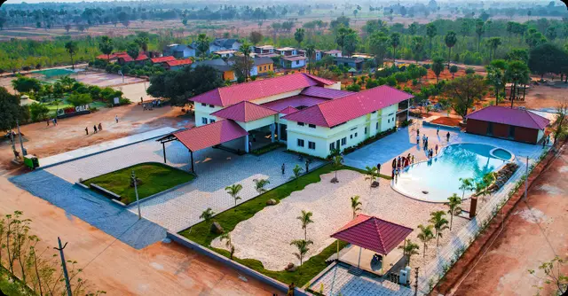
| Gym, children’s play area, community hall, clubhouse, swimming pool and jogging track | No sizes or capacities supplied | Third-party vendor listing Promoter website | Marketing-listed only; not established by the supplied RERA layout evidence |
7. Utilities, building services & safety
The RERA amenities record lists water supply, sewerage, storm-water drains, street lighting, sewage/sullage treatment and disposal, solid-waste management, rainwater harvesting, energy management, fire protection, and an electrical meter room/sub-station/receiving station. The record provides no system specifications, capacities, detailed drawings, or independent evidence of installation or completion. Items without an explicit “YES” are not treated here as confirmed provision. RERA amenities
The KUDA proceeding identifies a 202 sq. m garbage area. Form B declares that the promoter will comply with the separate-account and project obligations stated in the filing, but this is a promoter declaration and does not establish the present status of utilities or services.
8. Location, access & connectivity
The registered project location is in Station Ghanpur Mandal, Ghanpur (Stn), Jangaon district, PIN 506221; the filed layout proceeding identifies the revenue village as Raghavapur. The layout boundary schedule states that the east boundary is 60 M ROAD and identifies agricultural land to the west, north and south. The proceeding also includes a condition to develop an approach road. RERA record
The supplied location data includes a geocoded point described as a cadastral parcel centroid at 17.41528, 78.35459, and a listed distance of 1.2 km to Financial District (Nanakramguda). That connectivity record is not accompanied by a route or a project-specific travel-time estimate. Location record
9. Developer & development status
The registered promoter is PAKKA REALTORS, identified in the project record as a partnership, with GSTIN 36AAYFP2098M1Z7. The supplied party record lists PAKKA KOMURELLI and SANDRAGIRI SATISH KUMAR as partners and RAVI PAKKA as authorized signatory. The RERA certificate gives the promoter-office particulars as “Village: Mandal: Hanamkonda, District: Warangal Urban, Pin: 506001.” RERA filing Corporate record Parties record
In Form B, PAKA RAVI, on behalf of M/S PAKKA REALTORS, declares that the land is free from encumbrances and undertakes completion by 23-09-2025. These are the promoter’s filed declarations; the supplied material does not independently verify current site progress or completion.
10. Approvals, official records & documents
| Identifier / date | P00600005265; issued 28/10/2022; valid through 23/09/2025 |
|---|---|
| What the supplied record establishes | Registration under section 5 for ORUGALLU EMPIRE; certificate also states registration conditions, including a separate-account requirement. |
| Identifier / date | Approval/proceedings no. 13PMSNo.00341.1/16/KUDA/11052022/800; application no. C1/DPMS.No.000341/LT/U6/KUDA/11052022 |
|---|---|
| What the supplied record establishes | Describes the proposed open-plots layout and its land-use schedule; the extracted approval date is rendered as “2319-2022.” |
| Identifier / date | D.P.No. 75/2022 |
|---|---|
| What the supplied record establishes | Identified in the filed layout material. |
| Identifier / date | Attested 28-09-2022; verification date incomplete in OCR |
|---|---|
| What the supplied record establishes | Promoter declaration on title basis, encumbrances, funding, audit, approvals and completion undertaking. |
| Identifier / date | Dated 15-10-2022 |
|---|---|
| What the supplied record establishes | Advocate’s report concerning the listed land and title records. |
| Identifier / date | Deed nos. 1881/2021 and 122/2022 |
|---|---|
| What the supplied record establishes | Filed title materials describe transfers to Pakka Realtors; see Land & Title for the complete deed register and chain details. |
| Identifier / date | 3474/2022, dated 22-09-2022 |
|---|---|
| What the supplied record establishes | Filed as a mortgage associated with layout approval; the layout proceeding identifies plots 36, 48, 50, 51, 52 and 57 as the six mortgage plots. |
| Identifier / date | Road deed 3472/2022 and open-space deed 3473/2022, both dated 22-09-2022 |
|---|---|
| What the supplied record establishes | Filed materials describe the road and open-space transfers. |
The supplied package contains no completion/occupancy certificate. The public approved-layout lookup is recorded as unavailable, so this overview relies on the filed layout proceeding and documents listed above rather than a separate public-portal confirmation. HMDA
1. Project at a glance
Project identity
Registered name: ORUGALLU EMPIRE
Project type: Plotted development; proposed open-plots layout
Phase / registered portion: Phase not separately identified in the supplied record; registration and layout refer to the project across the listed survey numbers
TG-RERA registration: P00600005265
Registration validity: 28/10/2022 to 23/09/2025; certificate records no extension
Registered promoter: PAKKA REALTORS, identified as a partnership
RERA status in supplied record: New Project; registration certificate issued. The recorded validity end date is distinct from the project’s completion undertaking below.
Land and geographic identity
Locality: Station Ghanpur Mandal
Revenue village: Raghavapur in the KUDA proceeding and title documents; the RERA land-details village field is not disclosed.
Mandal: Ghanpur (Stn) / Station Ghanpur
District: Jangaon; the KUDA proceeding spells this “Janagaon.”
PIN: 506221
Survey numbers and subdivisions: 164/2A/1, 164/2A/2/3, 164/1, 164/2, 164/1/1/2, 165/C, 165/E, 165/D, 166/B, 166/A
Registered extent: 21,959 sq. m (also stated as Ac. 05.17.03 gts)
Net / total area: RERA land record: total and net area each 21,959 sq. m. KUDA layout proceeding separately identifies 12,145 sq. m as net plotted area.
Boundaries: East: 60 M ROAD; West: agriculture land of Krishnamurthy; North: agriculture land of Sripahda Jagannadham; South: agriculture land of R Uppachary.
RERA-declared mortgage area: 1,867.67 sq. m
Development identity
Sanctioning authority: Kakatiya Urban Development Authority (KUDA), as named in the filed proceeding
Principal layout approval: 13PMSNo.00341.1/16/KUDA/11052022/800; layout plan D.P.No. 75/2022
Approval date: The extracted date is recorded as “2319-2022” and is not legible as a reliable date in the supplied data.
Approved layout extent / stated on-ground area: Ac. 05.17.03 gts; 21,959.0 sq. m
Approved built-up area: 12,145 sq. m, as recorded in the RERA fields; the KUDA proceeding labels 12,145 sq. m as net plotted area.
Plots: 57 plots in the KUDA layout proceeding
Buildings, floors and parking levels: Not applicable to the filed open-plots layout; no building count, floor configuration or parking-level schedule is supplied.
Offering and status
Unit type: Plots; individual plot-size bands, plot numbers, and RERA unit inventory details are not supplied.
Booked / available counts: Not disclosed in the supplied project records.
Promoter-declared completion date: 23/09/2025, stated in Form B
Construction stage: The supplied data includes no independently verified site-progress assessment or dated construction-stage update.
Occupancy / completion certificate: No project completion or occupancy certificate is included in the supplied records.
Registration validity vs completion: Registration is recorded as valid through 23/09/2025; Form B separately undertakes completion by 23/09/2025. These are different record items, and neither establishes current completion or an issued certificate.
2. The project story
ORUGALLU EMPIRE is registered as a plotted development in the RERA record. The filed KUDA proceeding describes a proposed open-plots layout on land at Raghavapur village, Station Ghanpur Mandal, Jangaon district, covering the ten survey numbers and subdivisions listed above. It records a total layout extent of 21,959.0 sq. m and 57 plots.
The proceeding allocates land to net plotted area, roads, open space, social infrastructure and a garbage area. It also records six mortgage plots and refers to registered road and open-space gift deeds. Those are features and land allocations recorded in the layout documents; the supplied material does not establish the present on-site condition or completion of works.
The promoter’s Form B affidavit undertakes completion by 23/09/2025. The supplied evidence does not include a current progress report, site inspection, or completion/occupancy certificate, so the present development stage and delivery status cannot be confirmed from this record.
3. Master plan, architecture & building design
The filed KUDA proceeding describes a plotted layout rather than a building scheme. Its land-use schedule records:
Total layout area: 21,959.0 sq. m
Net plotted area: 12,145 sq. m (55.30%)
Proposed roads: 7,340.0 sq. m (33.42%)
Open space: 2,214.0 sq. m (10.08%)
Social infrastructure: 770 sq. m (3.5%)
Garbage area: 202 sq. m
Mortgage area: 1,867.67 sq. m (15.3%)
The proceeding states that plots 36, 48, 50, 51, 52 and 57—six plots in total—were mortgaged, and records registered gift deeds for roads and open space. It also lists “develop approach Road” among conditions.
No building arrangement, building footprint, floor configuration, tower height, internal building circulation, or residential/commercial building distribution is evidenced. The 12,145 sq. m figure is identified in the layout proceeding as net plotted area; the supplied records do not provide a separate building-area schedule for this plotted development.
4. Homes, configurations & floor plans
The RERA record identifies the offering as plots, and the filed layout proceeding states 57 plots. The supplied evidence does not give plot-size bands, plot-by-plot dimensions, booked or available counts, or a RERA-filed saleable-area schedule.
The available floor-plan record contains two drawings, with both scans pending measurement; no software-measured areas or plot measurements are supplied.
| Configuration | Units | Booked | Available | RERA saleable area | Measured carpet area | Loading |
|---|---|---|---|---|---|---|
| Plots | 57 (layout proceeding) | Not disclosed | Not disclosed | Not disclosed | Not applicable / not supplied | Not supplied |
5. Parking & vehicle circulation
The filed layout schedule identifies 7,340.0 sq. m as proposed roads, but does not provide a parking-space count, visitor or accessible parking allocation, or parking allotment arrangements for individual plots. It also lists development of an approach road as a condition. No evidence is supplied about the present construction status of roads, driveways, pedestrian separation, or EV charging.
6. Amenities, recreation & open spaces
The following facilities and land allocations appear in the supplied project records. The progress percentages in the RERA amenities data are recorded as 0; these are not independent site-verification findings.
| Facility | Description / size | Evidence source | Declared progress / verified status |
|---|---|---|---|
| Open space | 2,214.0 sq. m (10.08%) | KUDA layout proceeding | Layout allocation recorded; present physical condition not verified |
| Roads | 7,340.0 sq. m (33.42%) | KUDA layout proceeding | Proposed roads recorded; proceeding includes “develop approach Road” condition |
| Social infrastructure | 770 sq. m (3.5%) | KUDA layout proceeding | Land allocation recorded; facility details and completion not supplied |
| Garbage area / station | 202 sq. m | KUDA layout proceeding | Area recorded; present facility status not verified |
| Green strip / tot lot / park | No size supplied | RERA amenities | Listed “YES”; progress recorded as 0; completion not independently verified |
| Internal roads and footpaths | No dimensions supplied | RERA amenities | Listed “YES”; progress recorded as 0; completion not independently verified |
| Community buildings | No building or capacity details supplied | RERA amenities | Progress recorded as 0; no completion evidence supplied |
| Gym, children’s play area, community hall, clubhouse, swimming pool and jogging track | No sizes or capacities supplied | Third-party vendor listing | Marketing-listed only; not established by the supplied RERA layout evidence |
7. Utilities, building services & safety
The RERA amenities record lists water supply, sewerage, storm-water drains, street lighting, sewage/sullage treatment and disposal, solid-waste management, rainwater harvesting, energy management, fire protection, and an electrical meter room/sub-station/receiving station. The record provides no system specifications, capacities, detailed drawings, or independent evidence of installation or completion. Items without an explicit “YES” are not treated here as confirmed provision.
The KUDA proceeding identifies a 202 sq. m garbage area. Form B declares that the promoter will comply with the separate-account and project obligations stated in the filing, but this is a promoter declaration and does not establish the present status of utilities or services.
8. Location, access & connectivity
The registered project location is in Station Ghanpur Mandal, Ghanpur (Stn), Jangaon district, PIN 506221; the filed layout proceeding identifies the revenue village as Raghavapur. The layout boundary schedule states that the east boundary is 60 M ROAD and identifies agricultural land to the west, north and south. The proceeding also includes a condition to develop an approach road.
The supplied location data includes a geocoded point described as a cadastral parcel centroid at 17.41528, 78.35459, and a listed distance of 1.2 km to Financial District (Nanakramguda). That connectivity record is not accompanied by a route or a project-specific travel-time estimate.
9. Developer & development status
The registered promoter is PAKKA REALTORS, identified in the project record as a partnership, with GSTIN 36AAYFP2098M1Z7. The supplied party record lists PAKKA KOMURELLI and SANDRAGIRI SATISH KUMAR as partners and RAVI PAKKA as authorized signatory. The RERA certificate gives the promoter-office particulars as “Village: Mandal: Hanamkonda, District: Warangal Urban, Pin: 506001.”
In Form B, PAKA RAVI, on behalf of M/S PAKKA REALTORS, declares that the land is free from encumbrances and undertakes completion by 23-09-2025. These are the promoter’s filed declarations; the supplied material does not independently verify current site progress or completion.
10. Approvals, official records & documents
| Identifier / date | P00600005265; issued 28/10/2022; valid through 23/09/2025 |
|---|---|
| What the supplied record establishes | Registration under section 5 for ORUGALLU EMPIRE; certificate also states registration conditions, including a separate-account requirement. |
| Identifier / date | Approval/proceedings no. 13PMSNo.00341.1/16/KUDA/11052022/800; application no. C1/DPMS.No.000341/LT/U6/KUDA/11052022 |
|---|---|
| What the supplied record establishes | Describes the proposed open-plots layout and its land-use schedule; the extracted approval date is rendered as “2319-2022.” |
| Identifier / date | D.P.No. 75/2022 |
|---|---|
| What the supplied record establishes | Identified in the filed layout material. |
| Identifier / date | Attested 28-09-2022; verification date incomplete in OCR |
|---|---|
| What the supplied record establishes | Promoter declaration on title basis, encumbrances, funding, audit, approvals and completion undertaking. |
| Identifier / date | Dated 15-10-2022 |
|---|---|
| What the supplied record establishes | Advocate’s report concerning the listed land and title records. |
| Identifier / date | Deed nos. 1881/2021 and 122/2022 |
|---|---|
| What the supplied record establishes | Filed title materials describe transfers to Pakka Realtors; see Land & Title for the complete deed register and chain details. |
| Identifier / date | 3474/2022, dated 22-09-2022 |
|---|---|
| What the supplied record establishes | Filed as a mortgage associated with layout approval; the layout proceeding identifies plots 36, 48, 50, 51, 52 and 57 as the six mortgage plots. |
| Identifier / date | Road deed 3472/2022 and open-space deed 3473/2022, both dated 22-09-2022 |
|---|---|
| What the supplied record establishes | Filed materials describe the road and open-space transfers. |
The supplied package contains no completion/occupancy certificate. The public approved-layout lookup is recorded as unavailable, so this overview relies on the filed layout proceeding and documents listed above rather than a separate public-portal confirmation.
Frequently asked questions
Is ORUGALLU EMPIRE registered with Telangana RERA?
Yes. ORUGALLU EMPIRE is registered with the Telangana Real Estate Regulatory Authority as P00600005265; the registration status is New Project.
Who is the developer of ORUGALLU EMPIRE?
The promoter named in the RERA registration is PAKKA REALTORS.
Where is ORUGALLU EMPIRE located?
ORUGALLU EMPIRE is in STATION GHANPUR MANDAL, Ghanpur (Stn), Jangaon, Telangana (506221).
When will ORUGALLU EMPIRE be completed?
The promoter's proposed date of completion filed with RERA is 23/09/2025. This is the promoter's declaration, not a guarantee.
More projects in Ghanpur