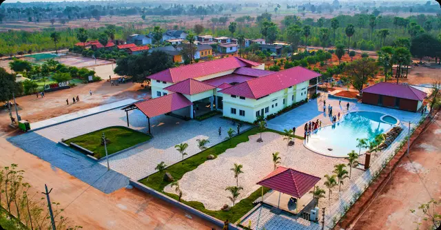
Highway Meadows
NAVATHA HOMES · Jangaon · RERA P00600006573
Highway Meadows is a plotted development in Nidigonda, Raghunathpally Mandal, Jangaon District. The registered promoter is NAVATHA HOMES, and the TG-RERA record states a registered site extent of 14,481.34 sq m. The layout drawing shows plot numbers 1 to 625; the offering is plots, with plot sizes not disclosed in the supplied RERA data. The project is registered under TG-RERA number P00600006573, with proposed completion on 12/04/2025.
More from Navatha Homes · 2 projects →
01What we found
Read from TG-RERA filings, approvals, land and registration records and court records. A court case is counted only when the court record states this project's survey number with its village, or names the project.
02Check before you pay
9 items to check before you pay, 3 high - from the title chain, court records and approvals, each with what to ask the builder or your advocate. An item may not be a problem with the project: records can be incomplete.
1. Project at a glance
Project identity
| Field | Record |
|---|---|
| Registered project | Highway Meadows RERA record |
| Project type / phase | Plotted development; registered portion or phase not separately identified in the supplied record RERA record |
| TG-RERA registration | P00600006573 |
| Registration validity | Issued 07/07/2023; stated valid through 12/04/2025. The certificate records no extension. Registration validity is distinct from the project completion deadline. |
| Registered promoter | NAVATHA HOMES RERA record |
| RERA status | The supplied certificate records registration. It does not establish current registration status after the stated validity end date. |
Land and geographic identity
| Field | Record |
|---|---|
| Locality / site description | Next to NH 169, Behind SL Himaja, Fatheshapur RERA record RERA filing |
| Revenue village | Nidigonda RERA record RERA filing |
| Mandal / district / PIN | Raghunathpally / Jangaon / 506244 RERA record |
| Project survey numbers and subdivisions | 169/1/2/1/2 and 169/3/C |
| Registered site extent | 14,481.34 sq m total and net, as recorded in the TG-RERA project fields RERA filing |
| Boundaries | East: 60 FT Road and SL HIMAJA; West: DAMERA SRINU; North: SL HIMAJA; South: MEKALA SOMI REDDY RERA filing |
Development identity
| Field | Record |
|---|---|
| Sanctioning authority and principal approval | Hyderabad Metropolitan Development Authority (HMDA); layout approval 000255/LO/Plg/HMDA/2019, dated 23 August, 2019 Approvals record |
| Further layout record | Final Layout Letter under the same approval number, dated 23 January, 2023 Approvals record |
| Approved built-up area | 8360.43 sq m is recorded in the project fields as approved built-up area; the supplied records do not provide a building-by-building breakdown. RERA filing |
| Building / plot arrangement | The project is registered as a plotted development. The drawing-derived layout record shows plot numbers 1 to 625; no building or tower count is established by the RERA record supplied here. RERA record Layout record |
| Sanctioned floor configuration / parking | Not disclosed in the supplied project evidence; no residential building floor or parking-level configuration is established. Document index Approvals record |
Offering and status
| Field | Record |
|---|---|
| Unit type | Plots; the supplied RERA record does not provide a plot-size schedule or unit-level inventory. RERA record RERA filing |
| RERA saleable-size range | Not disclosed in the supplied RERA data. RERA filing |
| Booked / available counts | Not disclosed in the supplied evidence. RERA filing |
| Construction stage | No independently verified site-progress assessment is supplied. The project is registered as a new project; a current construction stage is not established by that label. RERA record Document index |
| Completion date | TG-RERA project fields state 12/04/2025 as proposed completion. Registration validity ended on the same date, but these are separate records and neither establishes completion. RERA filing |
| Original / revised dates | A Form-B filed for M/s. MAHATHI INFRA DEVELOPERS INDIA PVT LTD states an undertaking to complete by 23r August 2022; the supplied record does not identify this as the registered promoter’s current completion date. No revised completion date is established beyond the TG-RERA project-field date above. RERA filing |
| Occupancy / completion certificate | Not applicable to a plot as a unit in the same way as an apartment OC; the supplied records do not establish project-wide completion certification for Highway Meadows. Document index |
2. The project story
Highway Meadows is registered with TG-RERA as a plotted development in Nidigonda revenue village, Raghunathpally Mandal, Jangaon District. The registered site is described as being next to NH 169, behind SL Himaja, at Fatheshapur. Its registered land identity is survey numbers 169/1/2/1/2 and 169/3/C. The registered location is Nidigonda, Raghunathpally Mandal, Jangaon District, PIN 506244, described in the project record as Next to NH 169, Behind SL Himaja, Fatheshapur. The registered boundary description identifies a 60 FT Road on the east, alongside SL HIMAJA; the other boundaries name SL HIMAJA to the north, DAMERA SRINU to the west and MEKALA SOMI REDDY to the south. RERA record RERA filing RERA filing
The RERA record identifies plots as the offering, but does not supply plot-by-plot dimensions, an inventory schedule, or booked and available counts. The layout drawing’s text was read by software as showing plot numbers 1 to 625; this is a drawing-derived count and is not a RERA-disclosed inventory count. No site inspection or independently verified construction-progress record is included. RERA filing Layout record Document index
A supplied geospatial record places the cadastral parcel centroid at 17.75370, 79.23787. The nearest sampled Outer Ring Road interchange is listed at 68.1 km; this is a measured-distance record, not a travel-time estimate. Cadastral map Location record
3. Master plan, architecture & building design
The project’s RERA-recorded land extent is 14,481.34 sq m. Separately, the layout drawing has a stated total and net layout area of 204,409.67 sq m; its software-read area statement identifies 121,939.68 sq m as plotted area, 59,733.62 sq m as roads, 17,618.61 sq m as parks/open space, and 5,114.96 sq m as social infrastructure, with amenities area shown as 0.00 sq m. These drawing-derived figures describe the layout document, not the RERA-recorded site extent. RERA filing Layout record
HMDA’s final layout record identifies a residential open-plot layout and says roads and open spaces were taken over by the local authority through a registered gift deed. It also records a relinquishment deed concerning mortgaged plots. The final layout conditions state that individual building permissions are to be considered under the applicable building rules; no individual plot building design or floor configuration is supplied here.
The layout record lists internal roads, footpaths, storm-water drainage, water-supply lines, street lighting, parks, avenue planting, rainwater-harvesting pits, a transformer yard, underground utility ducting and cycling tracks among its development requirements. The supplied evidence does not establish their present on-site completion. RERA amenities
4. Homes, configurations & floor plans
The registered offering is plots. TG-RERA unit-level configuration counts, plot-size bands, booked/available inventory and saleable areas are not supplied. The table below therefore distinguishes the RERA disclosure from the limited drawing-derived information.
| Configuration | Units | Booked | Available | RERA saleable area | Measured carpet area | Loading (if supplied) |
|---|---|---|---|---|---|---|
| Plots | Not disclosed in supplied RERA data | Not disclosed | Not disclosed | Not disclosed | Not applicable / not supplied | Not supplied |
The layout drawing’s printed plot numbers were software-read as 1 to 625, but the drawing record says the plot list is incomplete and no plot sizes were extracted. A vendor listing states a plot-size range of 166 Sq.Yds to 267 Sq.Yds; this is a vendor claim, not a TG-RERA-filed area schedule. Layout record Promoter website
Two floor-plan records are listed: one drawing is pending scan review and one has no flats. No software-measured carpet area or room dimensions are available. Floor plans
5. Parking & vehicle circulation
The supplied TG-RERA evidence does not state a parking-space count, parking allocation by plot, visitor or accessible parking, or a parking structure. No vehicle-space entitlement can be established from the supplied record. Document index RERA filing
The layout approval record calls for roads of 18 mts and above and 60 feet and above, and requires roads to remain open for access to neighbouring sites. It also refers to footpaths and cycling tracks. These are approval-record conditions; the supplied evidence does not verify their completion on site.
6. Amenities, recreation & open spaces
The RERA amenity record lists infrastructure and facility categories, but its progress percentages are recorded as 0 and do not establish completed facilities. The HMDA approval documents also set out layout-development requirements. The table separates those records from a third-party vendor’s amenity claims.
| Description / size | Internal roads; footpaths to be paved. Layout road area: 59,733.62 sq m in the drawing-derived area statement. |
|---|---|
| Evidence source | RERA amenities Layout record |
| Declared progress / verified status | RERA amenity progress recorded as 0; completion not independently verified. |
| Description / size | 17,618.61 sq m in the layout drawing; approval record describes organized open space. |
|---|---|
| Evidence source | Layout record |
| Declared progress / verified status | Approval/layout evidence; present condition not independently verified. |
| Description / size | 5,114.96 sq m in the layout drawing and HMDA draft-layout record. |
|---|---|
| Evidence source | Layout record |
| Declared progress / verified status | Approval record; present condition not independently verified. |
| Description / size | No size or facility description supplied. |
|---|---|
| Evidence source | RERA amenities |
| Declared progress / verified status | Progress recorded as 0; no completion evidence supplied. |
| Description / size | Rainwater-harvesting pits/structure are listed in the layout approval and final-layout record. |
|---|---|
| Evidence source | RERA amenities |
| Declared progress / verified status | Required/listed in approval records; completion not independently verified. |
| Description / size | Cycling tracks are listed in the approval conditions. |
|---|---|
| Declared progress / verified status | Approval condition; completion not independently verified. |
| Description / size | Vendor-listed amenities; no size or capacity supplied. |
|---|---|
| Evidence source | Promoter website |
| Declared progress / verified status | Vendor claims only; no project-specific completion evidence supplied. |
| Description / size | Vendor-listed amenities; no capacity or technical details supplied. |
|---|---|
| Evidence source | Promoter website |
| Declared progress / verified status | Vendor claims only; no project-specific completion evidence supplied. |
| Description / size | LED street lighting and avenue planting are listed in the approval record. |
|---|---|
| Declared progress / verified status | Approval conditions; completion not independently verified. |
7. Utilities, building services & safety
HMDA’s layout approval records call for water-supply arrangements, internal water-supply pipelines and an overhead tank; underground storm-water drainage; underground utility ducting; a transformer yard and street lighting; solid-waste disposal space; and rainwater-harvesting pits. The final layout record refers to water supply, sewerage and drainage-disposal systems, street lighting and rainwater-harvesting structures. These are approval-record descriptions and conditions, not verification that the services are complete or operational.
The RERA amenity form marks water supply, sewerage, storm-water drains, street lighting, water conservation/rainwater harvesting and an electrical meter room/substation/receiving station as available, while showing progress percentages of 0. The supplied documents do not provide capacities, water source details, treatment specifications, backup-power details, fire-system design, or accessibility provisions. RERA amenities
A vendor listing describes water supply as from a “Water Supply Corporation and Borewell” and lists sewage treatment, power backup, fire safety and CCTV; these are vendor claims, not verified technical or completion records for the project. Promoter website
8. Location, access & connectivity
See the project location, boundaries and geospatial details in The project story above.
9. Developer & development status
The TG-RERA registered promoter is NAVATHA HOMES, identified in the RERA fields as a Partnership and in the promoter information as an organization. The GSTIN recorded is 36AATFN8952F1ZM. The supplied evidence does not identify a company registration number or official website/contact details. VENKATESHWARLU NAGURLA is listed as the authorized signatory; the RERA-filed authorization letter is described as authorizing him to submit papers in connection with obtaining a RERA certificate. RERA filing Corporate record Parties record
The registration certificate records project registration through 12/04/2025 and no extension. The project fields state a proposed completion date of 12/04/2025. No current progress certification or independent site verification is supplied, so the present development stage cannot be confirmed from this evidence. RERA filing Document index
10. Approvals, official records & documents
| Supplied evidence | Form C, P00600006573, issued 07/07/2023, stated validity through 12/04/2025 |
|---|---|
| What it establishes | Registration identity, promoter name, stated validity and certificate conditions. |
| Supplied evidence | Approval 000255/LO/Plg/HMDA/2019, dated 23 August, 2019 |
|---|---|
| What it establishes | Draft open-plot layout approval record and listed development conditions; forwarded to Shadnagar Municipality for further action and release of plans. |
| Supplied evidence | Same approval number; dated 23 January, 2023 |
|---|---|
| What it establishes | Final residential open-plot layout record and conditions. It records roads/open spaces taken over by the local authority under registered gift deed 12762/2022 and a relinquishment deed 691/2023 concerning mortgaged plots. |
| Supplied evidence | Document 109563 Layout record |
|---|---|
| What it establishes | Drawing-derived plot numbering and area statement; plot list is incomplete and plot sizes were not extracted. |
| Supplied evidence | Document 318551 |
|---|---|
| What it establishes | OCR shows a largely incomplete declaration; promoter, project registration number, completion period and declaration date are not filled in in the extracted text. |
| Supplied evidence | Document 109567 |
|---|---|
| What it establishes | Form-B dated 6thday of December2020, made by an authorized signatory for M/s. MAHATHI INFRA DEVELOPERS INDIA PVT LTD, with a stated completion undertaking of 23r August 2022. |
| Supplied evidence | No project-specific completion or occupancy certificate for Highway Meadows is supplied. Document index |
|---|---|
| What it establishes | The final layout record is not presented here as a project-wide completion or occupancy certificate. |
1. Project at a glance
Project identity
Registered project: Highway Meadows
Project type / phase: Plotted development; registered portion or phase not separately identified in the supplied record
TG-RERA registration: P00600006573
Registration validity: Issued 07/07/2023; stated valid through 12/04/2025. The certificate records no extension. Registration validity is distinct from the project completion deadline.
Registered promoter: NAVATHA HOMES
RERA status: The supplied certificate records registration. It does not establish current registration status after the stated validity end date.
Land and geographic identity
Locality / site description: Next to NH 169, Behind SL Himaja, Fatheshapur
Revenue village: Nidigonda
Mandal / district / PIN: Raghunathpally / Jangaon / 506244
Project survey numbers and subdivisions: 169/1/2/1/2 and 169/3/C
Registered site extent: 14,481.34 sq m total and net, as recorded in the TG-RERA project fields
Boundaries: East: 60 FT Road and SL HIMAJA; West: DAMERA SRINU; North: SL HIMAJA; South: MEKALA SOMI REDDY
Development identity
Sanctioning authority and principal approval: Hyderabad Metropolitan Development Authority (HMDA); layout approval 000255/LO/Plg/HMDA/2019, dated 23 August, 2019
Further layout record: Final Layout Letter under the same approval number, dated 23 January, 2023
Approved built-up area: 8360.43 sq m is recorded in the project fields as approved built-up area; the supplied records do not provide a building-by-building breakdown.
Building / plot arrangement: The project is registered as a plotted development. The drawing-derived layout record shows plot numbers 1 to 625; no building or tower count is established by the RERA record supplied here.
Sanctioned floor configuration / parking: Not disclosed in the supplied project evidence; no residential building floor or parking-level configuration is established.
Offering and status
Unit type: Plots; the supplied RERA record does not provide a plot-size schedule or unit-level inventory.
RERA saleable-size range: Not disclosed in the supplied RERA data.
Booked / available counts: Not disclosed in the supplied evidence.
Construction stage: No independently verified site-progress assessment is supplied. The project is registered as a new project; a current construction stage is not established by that label.
Completion date: TG-RERA project fields state 12/04/2025 as proposed completion. Registration validity ended on the same date, but these are separate records and neither establishes completion.
Original / revised dates: A Form-B filed for M/s. MAHATHI INFRA DEVELOPERS INDIA PVT LTD states an undertaking to complete by 23r August 2022; the supplied record does not identify this as the registered promoter’s current completion date. No revised completion date is established beyond the TG-RERA project-field date above.
Occupancy / completion certificate: Not applicable to a plot as a unit in the same way as an apartment OC; the supplied records do not establish project-wide completion certification for Highway Meadows.
2. The project story
Highway Meadows is registered with TG-RERA as a plotted development in Nidigonda revenue village, Raghunathpally Mandal, Jangaon District. The registered site is described as being next to NH 169, behind SL Himaja, at Fatheshapur. Its registered land identity is survey numbers 169/1/2/1/2 and 169/3/C. The registered location is Nidigonda, Raghunathpally Mandal, Jangaon District, PIN 506244, described in the project record as Next to NH 169, Behind SL Himaja, Fatheshapur. The registered boundary description identifies a 60 FT Road on the east, alongside SL HIMAJA; the other boundaries name SL HIMAJA to the north, DAMERA SRINU to the west and MEKALA SOMI REDDY to the south.
The RERA record identifies plots as the offering, but does not supply plot-by-plot dimensions, an inventory schedule, or booked and available counts. The layout drawing’s text was read by software as showing plot numbers 1 to 625; this is a drawing-derived count and is not a RERA-disclosed inventory count. No site inspection or independently verified construction-progress record is included.
A supplied geospatial record places the cadastral parcel centroid at 17.75370, 79.23787. The nearest sampled Outer Ring Road interchange is listed at 68.1 km; this is a measured-distance record, not a travel-time estimate.
3. Master plan, architecture & building design
The project’s RERA-recorded land extent is 14,481.34 sq m. Separately, the layout drawing has a stated total and net layout area of 204,409.67 sq m; its software-read area statement identifies 121,939.68 sq m as plotted area, 59,733.62 sq m as roads, 17,618.61 sq m as parks/open space, and 5,114.96 sq m as social infrastructure, with amenities area shown as 0.00 sq m. These drawing-derived figures describe the layout document, not the RERA-recorded site extent.
HMDA’s final layout record identifies a residential open-plot layout and says roads and open spaces were taken over by the local authority through a registered gift deed. It also records a relinquishment deed concerning mortgaged plots. The final layout conditions state that individual building permissions are to be considered under the applicable building rules; no individual plot building design or floor configuration is supplied here.
The layout record lists internal roads, footpaths, storm-water drainage, water-supply lines, street lighting, parks, avenue planting, rainwater-harvesting pits, a transformer yard, underground utility ducting and cycling tracks among its development requirements. The supplied evidence does not establish their present on-site completion.
4. Homes, configurations & floor plans
The registered offering is plots. TG-RERA unit-level configuration counts, plot-size bands, booked/available inventory and saleable areas are not supplied. The table below therefore distinguishes the RERA disclosure from the limited drawing-derived information.
| Configuration | Units | Booked | Available | RERA saleable area | Measured carpet area | Loading (if supplied) |
|---|---|---|---|---|---|---|
| Plots | Not disclosed in supplied RERA data | Not disclosed | Not disclosed | Not disclosed | Not applicable / not supplied | Not supplied |
The layout drawing’s printed plot numbers were software-read as 1 to 625, but the drawing record says the plot list is incomplete and no plot sizes were extracted. A vendor listing states a plot-size range of 166 Sq.Yds to 267 Sq.Yds; this is a vendor claim, not a TG-RERA-filed area schedule.
Two floor-plan records are listed: one drawing is pending scan review and one has no flats. No software-measured carpet area or room dimensions are available.
5. Parking & vehicle circulation
The supplied TG-RERA evidence does not state a parking-space count, parking allocation by plot, visitor or accessible parking, or a parking structure. No vehicle-space entitlement can be established from the supplied record.
The layout approval record calls for roads of 18 mts and above and 60 feet and above, and requires roads to remain open for access to neighbouring sites. It also refers to footpaths and cycling tracks. These are approval-record conditions; the supplied evidence does not verify their completion on site.
6. Amenities, recreation & open spaces
The RERA amenity record lists infrastructure and facility categories, but its progress percentages are recorded as 0 and do not establish completed facilities. The HMDA approval documents also set out layout-development requirements. The table separates those records from a third-party vendor’s amenity claims.
| Description / size | Internal roads; footpaths to be paved. Layout road area: 59,733.62 sq m in the drawing-derived area statement. |
|---|---|
| Declared progress / verified status | RERA amenity progress recorded as 0; completion not independently verified. |
| Description / size | 17,618.61 sq m in the layout drawing; approval record describes organized open space. |
|---|---|
| Declared progress / verified status | Approval/layout evidence; present condition not independently verified. |
| Description / size | 5,114.96 sq m in the layout drawing and HMDA draft-layout record. |
|---|---|
| Declared progress / verified status | Approval record; present condition not independently verified. |
| Description / size | No size or facility description supplied. |
|---|---|
| Declared progress / verified status | Progress recorded as 0; no completion evidence supplied. |
| Description / size | Rainwater-harvesting pits/structure are listed in the layout approval and final-layout record. |
|---|---|
| Declared progress / verified status | Required/listed in approval records; completion not independently verified. |
| Description / size | Cycling tracks are listed in the approval conditions. |
|---|---|
| Declared progress / verified status | Approval condition; completion not independently verified. |
| Description / size | Vendor-listed amenities; no size or capacity supplied. |
|---|---|
| Declared progress / verified status | Vendor claims only; no project-specific completion evidence supplied. |
| Description / size | Vendor-listed amenities; no capacity or technical details supplied. |
|---|---|
| Declared progress / verified status | Vendor claims only; no project-specific completion evidence supplied. |
| Description / size | LED street lighting and avenue planting are listed in the approval record. |
|---|---|
| Declared progress / verified status | Approval conditions; completion not independently verified. |
7. Utilities, building services & safety
HMDA’s layout approval records call for water-supply arrangements, internal water-supply pipelines and an overhead tank; underground storm-water drainage; underground utility ducting; a transformer yard and street lighting; solid-waste disposal space; and rainwater-harvesting pits. The final layout record refers to water supply, sewerage and drainage-disposal systems, street lighting and rainwater-harvesting structures. These are approval-record descriptions and conditions, not verification that the services are complete or operational.
The RERA amenity form marks water supply, sewerage, storm-water drains, street lighting, water conservation/rainwater harvesting and an electrical meter room/substation/receiving station as available, while showing progress percentages of 0. The supplied documents do not provide capacities, water source details, treatment specifications, backup-power details, fire-system design, or accessibility provisions.
A vendor listing describes water supply as from a “Water Supply Corporation and Borewell” and lists sewage treatment, power backup, fire safety and CCTV; these are vendor claims, not verified technical or completion records for the project.
8. Location, access & connectivity
See the project location, boundaries and geospatial details in The project story above.
9. Developer & development status
The TG-RERA registered promoter is NAVATHA HOMES, identified in the RERA fields as a Partnership and in the promoter information as an organization. The GSTIN recorded is 36AATFN8952F1ZM. The supplied evidence does not identify a company registration number or official website/contact details. VENKATESHWARLU NAGURLA is listed as the authorized signatory; the RERA-filed authorization letter is described as authorizing him to submit papers in connection with obtaining a RERA certificate.
The registration certificate records project registration through 12/04/2025 and no extension. The project fields state a proposed completion date of 12/04/2025. No current progress certification or independent site verification is supplied, so the present development stage cannot be confirmed from this evidence.
10. Approvals, official records & documents
| Supplied evidence | Form C, P00600006573, issued 07/07/2023, stated validity through 12/04/2025 |
|---|---|
| What it establishes | Registration identity, promoter name, stated validity and certificate conditions. |
| Supplied evidence | Approval 000255/LO/Plg/HMDA/2019, dated 23 August, 2019 |
|---|---|
| What it establishes | Draft open-plot layout approval record and listed development conditions; forwarded to Shadnagar Municipality for further action and release of plans. |
| Supplied evidence | Same approval number; dated 23 January, 2023 |
|---|---|
| What it establishes | Final residential open-plot layout record and conditions. It records roads/open spaces taken over by the local authority under registered gift deed 12762/2022 and a relinquishment deed 691/2023 concerning mortgaged plots. |
| Supplied evidence | Document 109563 |
|---|---|
| What it establishes | Drawing-derived plot numbering and area statement; plot list is incomplete and plot sizes were not extracted. |
| Supplied evidence | Document 318551 |
|---|---|
| What it establishes | OCR shows a largely incomplete declaration; promoter, project registration number, completion period and declaration date are not filled in in the extracted text. |
| Supplied evidence | Document 109567 |
|---|---|
| What it establishes | Form-B dated 6thday of December2020, made by an authorized signatory for M/s. MAHATHI INFRA DEVELOPERS INDIA PVT LTD, with a stated completion undertaking of 23r August 2022. |
| Supplied evidence | No project-specific completion or occupancy certificate for Highway Meadows is supplied. |
|---|---|
| What it establishes | The final layout record is not presented here as a project-wide completion or occupancy certificate. |
Frequently asked questions
Is Highway Meadows registered with Telangana RERA?
Yes. Highway Meadows is registered with the Telangana Real Estate Regulatory Authority as P00600006573; the registration status is New Project.
Who is the developer of Highway Meadows?
The promoter named in the RERA registration is NAVATHA HOMES.
Where is Highway Meadows located?
Highway Meadows is in Next to NH 169, Behind SL Himaja, Fatheshapur, Nidigonda, Raghunathpally, Jangaon, Telangana (506244).
When will Highway Meadows be completed?
The promoter's proposed date of completion filed with RERA is 12/04/2025. This is the promoter's declaration, not a guarantee.
More projects in Raghunathpally